

chevron_left
chevron_right
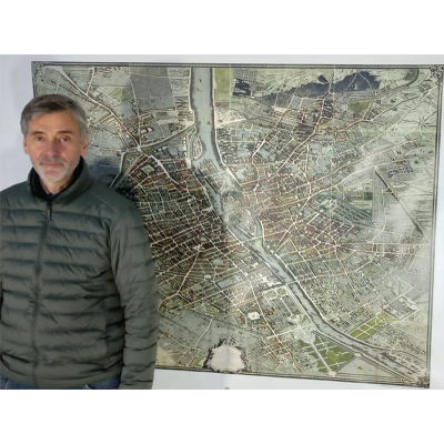
Plan de Paris dit plan de Turgot en couleurs, assemblé et imprimé sur bache : Echelle 1/2
Louis Bretez - PLAN DE PARIS dit PLAN DE TURGOT, 1734-1739
Les bâches sont imprimées à la demande sous 5 à 15 jours environ.
Ce Plan de Paris, commencé l’année 1734, a été dressé sous les ordres de Michel Étienne Turgot, prévôt des marchands de la capitale. Sa gravure achevée en 1739 nous livre sans doute le plus beau plan de Paris de l’avant-Révolution, le dernier conçu « à vue d’oiseau ». Il contient les 20 planches levées et dessinées par Louis Bretez, gravées par Claude Lucas et écrites par Aubin, et un plan d’ensemble.
Voici la première et l'unique réédition en couleur de ce célèbre plan. Les 20 planches ont été assemblées et le plan dans sa globalité est imprimé sur PVC. Ce plan de 140x185 cm est à l'échelle 1/2 (format de la bache 2mx1,6 m).
Ce format pourra agrémenter votre salon, votre entrée, vos bureaux et salles de réunion. Le plus beau plan de Paris et le plus grand témoignage du XVIIIe siècle.
Imprimé sur commande ! N'hésitez pas à nous consulter
Le site Actualitté, les univers du livre parle de notre plan. Superbe article très complet à lire absolument :
https://actualitte.com/article/109110/livres-anciens/voyager-dans-paris-avant-les-travaux-du-baron-haussmannIn 1734, Michel-Étienne Turgot, provost of merchants in the City of Paris, commissioned from Louis Bretez, sculptor, painter and perspective specialist, member of the Real Academy of Painting and Sculpture, a very faithful map representing all the beauties of the capital of the Realm of France.
In order to represent Paris “as it is”, with all details, Bretez worked in the field with its assistants, from 1734 to 1736. He was allowed to enter buildings so he could sketch the courtyards, gardens, and interior facades we see now on his “Plan de Turgot”.
Louis Bretez used for his monumental map the conventional bird’s eye perspective or “perspective cavalière”: two buildings of the same size are represented by two drawings of the same size, whether the buildings are close or distant. The scale is 1/1400, the map is oriented toward the southeast, as churches were, and offers an oblique view of the big city and its suburbs, like Montmartre.
In 1736, Claude Lucas, graver of the Academy of Sciences, created the 20 sheets of this huge plan, with a final publication in 1739. Beautifuly bound volumes were offered king Louis XV and foreign dignitaries, one copy even being sent to the court of the emperor in China. The 20 original ungraved plates are still conserved by the Chalcography of the Louvre, where they are yet used now.
Plan-turgot-bache-1-2
1 Livre
9791091890052
feedback Signaler le commentaire